Google Mapplet That Shows Flickr Photos
In addition to the Google Maps API, which allows a developer to embed Google Maps on a third-party site, Google recently introduced Google Mapplets as a way of adding extensions to Google Maps directly as little applications that run in a side panel. (Any mapplet you install and turn on interacts with the same map. For example, if you are using a mapplet for displaying flower shops and another one that displays restaurants, the resulting Google map shows both flower shops and restaurants.) You can find developer information here:
http://www.google.com/apis/maps/documentation/mapplets/
In this section, I’ll show you how to create a basic mapplet to display Flickr geotagged photos. Mapplets are a combination of JavaScript and HTML, embedded in an XML file. The methods you use are similar but not identical to those found in the Google Maps API, and there’s no need to write any server-side components. The Mapplets API provides wrappers for XHR that talk to the Google servers (which in turn act like server-side proxies that we wrote in PHP).
You can find the source for a mapplet that allows users to search for Flickr pictures of a certain tag here:
http://examples.mashupguide.net/ch10/flickr.mapplet.xml
Add the mapplet to your collection of maps. (See “Adding a Google Mapplet to Your Google My Maps.”)
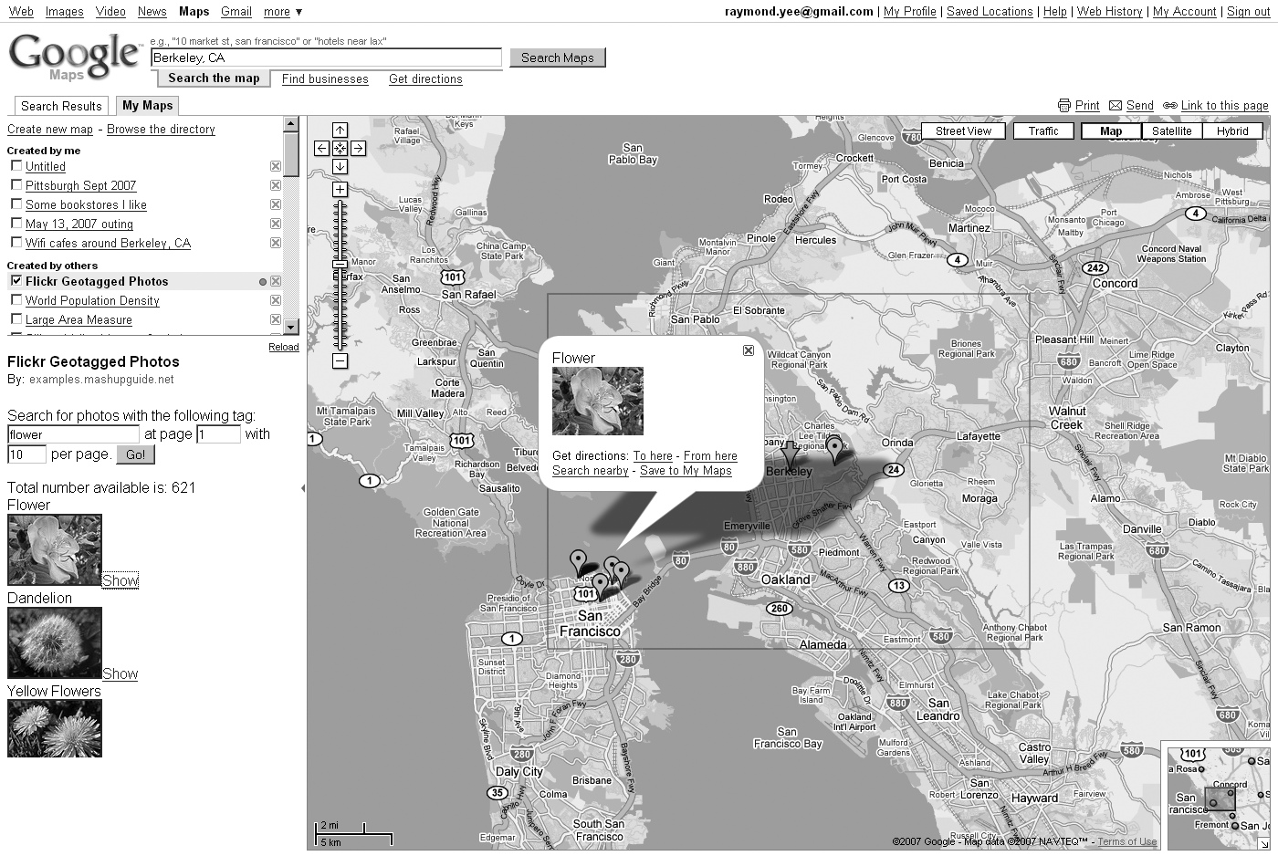
Figure 10-3 shows the mapplet in action.
The source is as follows:
<?xml version="1.0" encoding="UTF-8"?>
<Module>
<ModulePrefs title="Flickr Geotagged Photos"
             description="Show Flickr photos"
             author="Raymond Yee"
             author_email="raymondyee@mashupguide.net"
             height="150">
  <Require feature="sharedmap"/>
</ModulePrefs>
<Content type="html"><![CDATA[

<script>

  var map = new GMap2();
  var border = null;

function genPhotoLink(photo) {
    var t_url = "http://farm" + photo.farm + ".static.flickr.com/" + photo.server +
      "/" + photo.id + "_" + photo.secret + "_" + "t.jpg";
    var p_url = "http://www.flickr.com/photos/" + photo.owner + "/" + photo.id;

    return '<a href="' + p_url + '">' + '<img alt="'+ photo.title + '"src="' +
      t_url + '"/>' + '</a>';
}

// Creates a marker at the given point with the given msg.
function createMarker(point, msg) {
  var marker = new GMarker(point);
  GEvent.addListener(marker, "click", function() {
    marker.openInfoWindowHtml(msg);
  });
  return marker;
}

function createMarkerAndDiv (point,msg) {
    var marker, e, anchors, alink

    marker = createMarker(point, msg);
    e = document.createElement("div");

    e.innerHTML = msg +  "<a href='#'>Show</a><br>"
    anchors = e.getElementsByTagName('a')
    alink = anchors[anchors.length-1];
    alink.onclick = function(){marker.openInfoWindowHtml(msg);}

    return [marker,e];
}

function cb(s) {
    var rsp = eval('(' + s + ')');
    var marker, e

    // clear the photos
    map.clearOverlays();

    // add border
    map.addOverlay(border);

    var pdiv = document.getElementById("pictures");
    pdiv.innerHTML = "Total number available is: " + rsp.photos.total + "<br/>";;

    // put the pictures on the map
    for (var i=0; i < rsp.photos.photo.length; i++) {
        var photo = rsp.photos.photo[i];

        var point = new GLatLng (photo.latitude, photo.longitude);
        var msg = photo.title + "<br>" + genPhotoLink(photo);

        md =  createMarkerAndDiv(point,msg);
        marker = md[0];
        e=md[1];

        map.addOverlay(marker);
        pdiv.appendChild(e);
     }
}

function get_pictures() {
    var API_KEY = "[API_KEY]";
    fForm = document.getElementById('FlickrForm');

    map.getBoundsAsync(function(bounds) {
      var lat0 = bounds.getSouthWest().lat();
      var lon0 = bounds.getSouthWest().lng();
      var lat1 = bounds.getNorthEast().lat();
      var lon1 = bounds.getNorthEast().lng();

      // add polyline to mark the search boundaries
      border  = new GPolygon([
        new GLatLng(lat0, lon0),
        new GLatLng(lat1, lon0),
        new GLatLng(lat1, lon1),
        new GLatLng(lat0,lon1),
        new GLatLng(lat0,lon0)
      ], "#ff0000", 2);

      var url = "http://api.flickr.com/services/rest/?method=flickr.photos.search" +
        "&api_key=" + API_KEY +
        "&bbox=" + lon0 + "%2C" + lat0 + "%2C" + lon1 + "%2C" + lat1  +
        "&per_page=" + fForm.per_page.value +
        "&page=" + fForm.page.value +
        "&format=json&nojsoncallback=1&extras=geo";

      var tagValue = fForm.tag.value;
      // search by tag only if the box is not blank.
      if (tagValue.length) {
        url = url + "&tags=" + fForm.tag.value;
      } else {
        url = url + "&min_upload_date=820483200";
      }

      _IG_FetchContent(url, cb);

    } //anonymous function
    ); //map.getBoundsAsync

} //get_pictures

</script>

<form action="#" onsubmit="get_pictures(); return false;" id="FlickrForm">
  <p>Search for photos with the following tag:
  <input type="text" size="20" name="tag" value="flower">
  at page <input type="text" size="4" name="page" value="1"> with
  <input type="text" size="3" name="per_page" value="10"> per page.
  <button type="submit">Go!</button></p>
</form>
<div id="pictures"></div>

]]></Content>
</Module>
A few words about the logic of this code:
This code is compact partly because the
_IG_FetchContent()method makes accessing the Flickr API fairly straightforward because you can code the URL directly to the Flickr API instead of having to create your own server-side proxy (such asflickrgeo.php).Mapplets do not provide much room to display content in the sidebar. Hence, the mapplet can be better optimized to make use of the small space.